
 Download:


-
Objective: This study aimed to analyze the spatiotemporal characteristics of dengue fever in Yunnan Province and its relationship with meteorological factors.
Methods: Circular and spatiotemporal scan analyses were performed to investigate dengue fever, and a negative binomial regression model was used to estimate the impact of meteorological factors on the incidence of dengue fever.
Results: The peak period of dengue fever cases in Yunnan Province was from August to October, with clustering observed in border prefectures.
Conclusion: Dengue fever in Yunnan Province exhibited distinct spatiotemporal clustering and was significantly influenced by meteorological factors, particularly temperature and precipitation. These findings highlight the importance of multidimensional surveillance and early warning systems.
-
Yunnan Province, located at the junction of the tropical and subtropical zones, presents distinct local characteristics in the epidemiology of dengue fever. However, research on the relationship between dengue fever and environmental factors in Yunnan Province is limited. This study utilized dengue fever surveillance data from 2012–2024 and employed multiple analytical methods to explore the spatiotemporal patterns and their association with meteorological factors. These findings provide insight into dengue transmission dynamics and offer a scientific basis for targeted prevention and control strategies.
Dengue fever case data from Yunnan Province between 2012–2024 were collected from the China Disease Prevention and Control Information System. Cases were confirmed according to the Dengue Fever Diagnosis and Treatment Guidelines. Meteorological data, including temperature, relative humidity, precipitation, and sunshine duration, were obtained from the China Meteorological Data Platform for all prefecture-level cities in Yunnan Province. All meteorological variables were collected at a monthly temporal resolution; monthly averages were used for temperature and relative humidity, whereas monthly cumulative values were used for precipitation and sunshine duration. Dengue fever cases were aggregated by prefecture and month, and meteorological variables from the same prefecture and month were matched to the corresponding monthly dengue incidence for subsequent regression analyses. The potential lag effects of meteorological factors on dengue transmission were not explicitly modeled in this study and are discussed as a limitation.
The circular distribution method was used to analyze the temporal rhythmic characteristics of dengue fever outbreaks (1–2), and the Rayleigh test was used to assess temporal clustering (3). The intensity of clustering was measured by the length of the M vector: M<0.2 indicates no seasonality; 0.2–0.4 indicates weak seasonality; 0.4–0.6 indicates moderate seasonality; 0.6–0.8 indicates strong seasonality; and 0.8–1.0 indicates pronounced seasonality.
Spatial and spatiotemporal clustering of dengue fever was identified using the SaTScan™ (version 10.1, Martin Kulldorff in collaboration with Information Management Services, Inc., Calverton, MD, USA; Harvard Medical School, Boston, MA, USA) based on a discrete Poisson probability model, where the maximum spatial scanning window was set to 50% of the population at risk, and the maximum temporal scanning window was set to 50% of the study period. The statistical significance of the identified clusters was evaluated using 999 Monte Carlo replications, and clusters with the maximum log-likelihood ratio (LLR) and P<0.05 were considered statistically significant.
In addition, a negative binomial regression model was constructed to assess the association between meteorological factors and dengue fever incidence. Meteorological variables were entered into the model in their original units and were not standardized. Therefore, the regression coefficients represent the change in dengue fever incidence associated with a one-unit increase in each variable (1 °C for temperature, 1 mm for precipitation, and 1% for relative humidity).
From 2012–2024, a total of 34,307 dengue fever cases were reported in Yunnan Province, including 31,575 cases among Chinese nationals and 2,732 cases among foreigners (Figure 1). Most cases were among farmers, homemakers, and unemployed individuals, accounting for 14,334 cases (41.78%, 14,334/34,307). This was followed by workers in the commercial services sector (5,337 cases, 15.56%) and students (2,666 cases, 7.77%). Additionally, imported cases totaled 5,719 (16.67%, 5,719/34,307), with 99.39% originating from Southeast Asia (5,684/5,719). Relatively few cases were imported from South Asia and Africa (14 and 21 cases, respectively) (
Supplementary Table S1 ).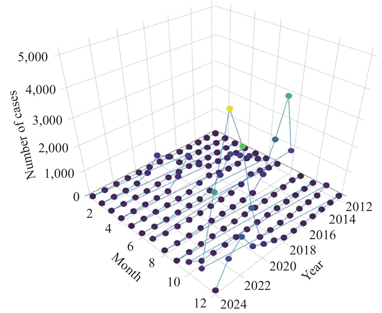 Figure 1.
Temporal distribution of dengue fever cases in Yunnan Province, China, 2012–2024.
Between 2012–2024, the overall incidence of dengue fever in Yunnan Province remained relatively stable, with noticeable seasonal fluctuations.
Circular distribution analysis identified the peak day of dengue fever incidence as October 10, with the peak period spanning from September 29 to October 20 and the overall epidemic period from September 20 to October 29. The Rayleigh test revealed statistically significant clustering (Z=23,691.32, P<0.001). The monthly values were presented in
Supplementary Table S2 and Figure 1. The concentration index ranged from 0.72 to 0.95, indicating strong seasonality (Supplementary Table S3 ).The overall incidence of dengue fever showed a gradual eastward spread from western regions, with cases predominantly concentrated in border areas such as Xishuangbanna and Dehong Prefectures (
Supplementary Table S4 ).A temporal scan was used to identify two clustering levels. The primary cluster was located in Xishuangbanna Prefecture, with a relative risk (RR) of 58.80 and a log-likelihood ratio (LLR) of 40,969.68 (P<0.001), occurring during the period from 2019–2024. Secondary clusters were detected in Baoshan City, Dehong Prefecture, and Lincang City, with an RR of 19.5 and an LLR of 10,711.39 (P<0.001) and were primarily clustered in 2023 (Table 1).
Type of clustering Location IDs included Time frame Number of cases Expected cases Population Relative risk Log likelihood ratio P Clusters Detected Primary 1 2019–2024 14,614 425.38 1,208,413 58.8 40,969.68 <0.001 Xishuangbanna Prefecture Secondary 3 2023 5,517 333.47 6,258,606 19.5 10,711.39 <0.001 Baoshan City, Dehong Prefecture, Lincang City Note: Clusters were identified using SaTScan based on a discrete Poisson model; location IDs refer to prefecture-level administrative units. Table 1. Spatiotemporal scan statistical analysis of dengue fever in Yunnan Province, China, 2012–2024.
The incidence of dengue fever was moderately correlated with temperature, humidity, and precipitation. Residual analysis indicated an overdispersion between the number of cases and meteorological factors (Figures 2–3).
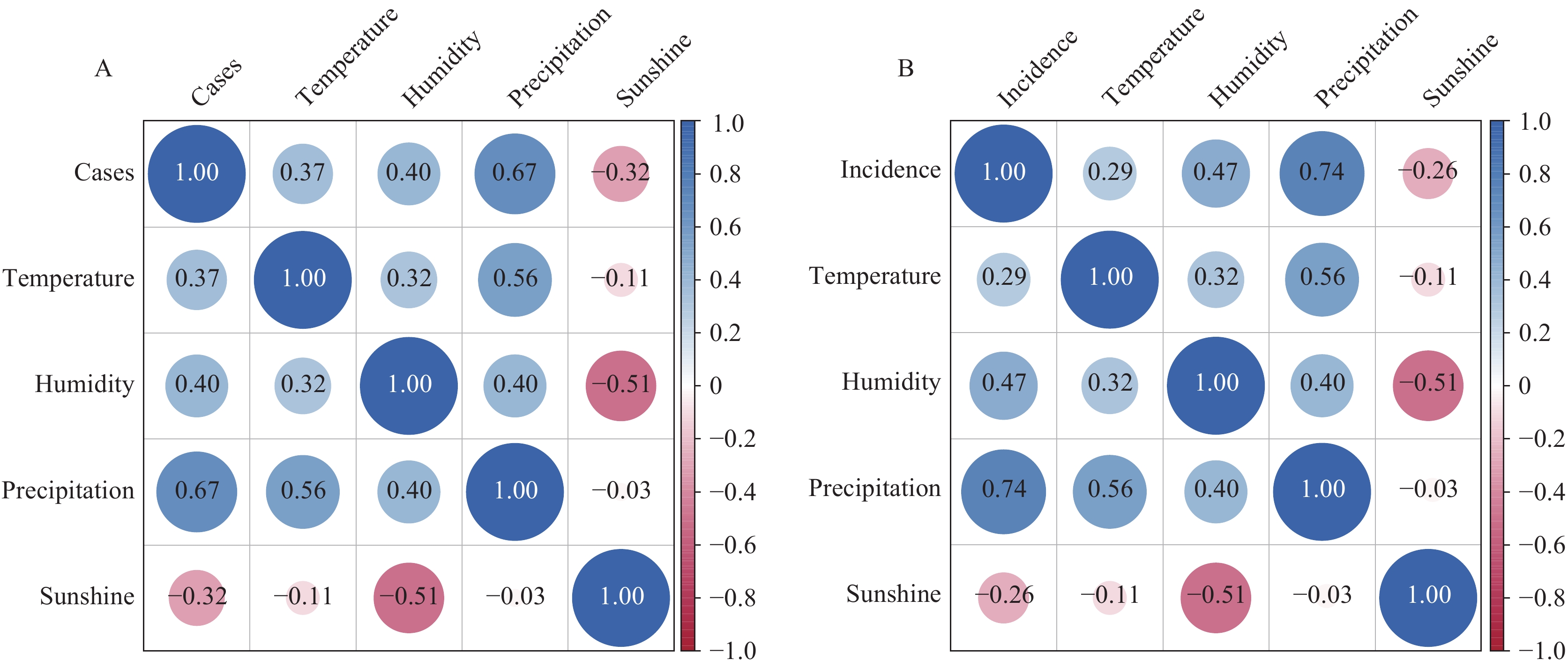 Figure 2.
Correlation coefficients between (A) dengue fever cases, or (B) incidence rates, and meteorological factors.
Note: Each correlation coefficient in the figure is represented by a circle; the size and color intensity of the circle indicate strength. Larger circles denote stronger correlation, whereas deeper colors signify higher correlation values; smaller circles with lighter colors represent weaker correlations. Residual diagnostics revealed clear evidence of overdispersion and heteroscedasticity in the relationship between dengue cases and meteorological factors. Therefore, a negative binomial regression model was adopted in place of the Poisson model.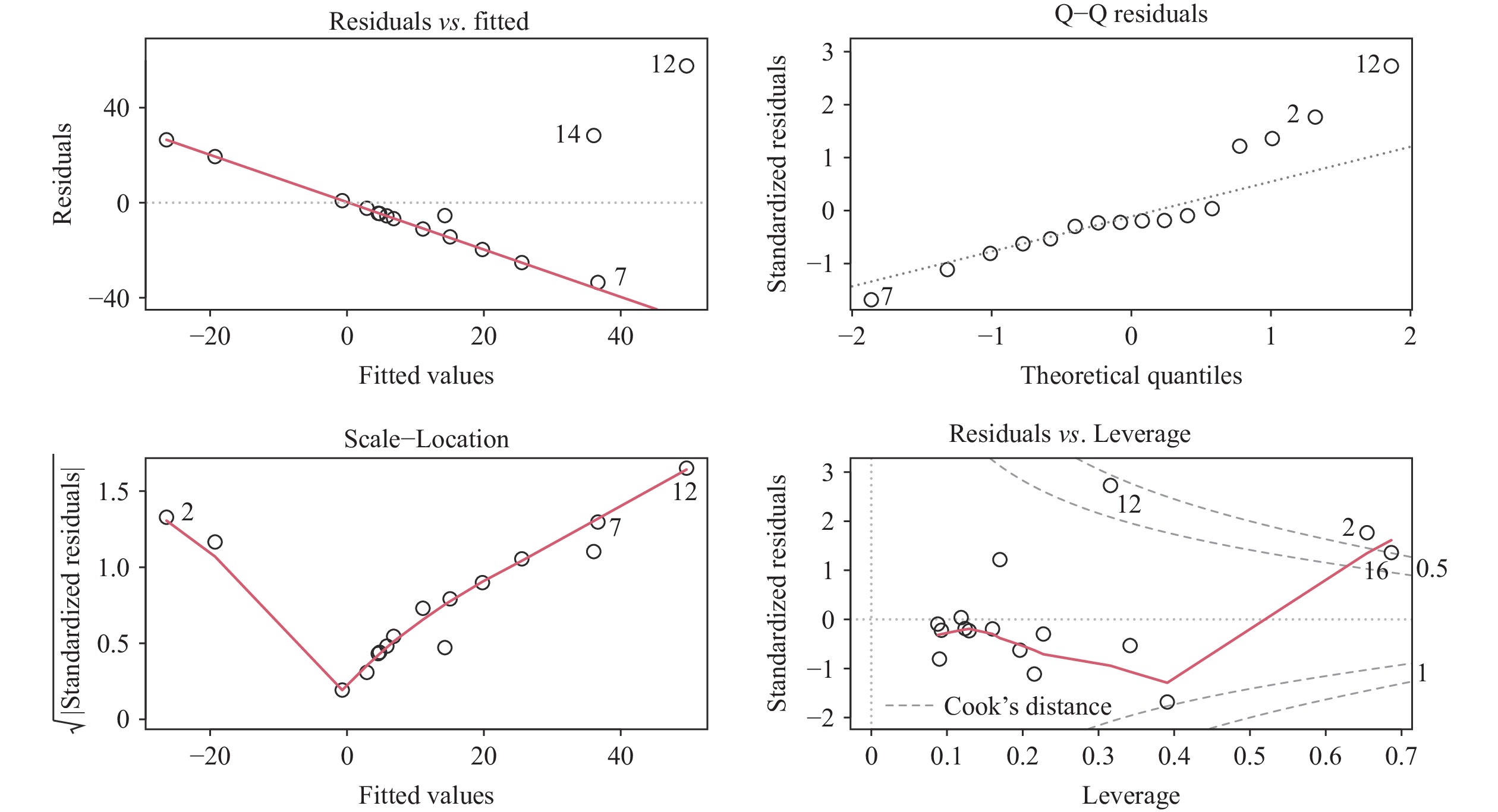 Figure 3.
Residual distribution plot.
The negative binomial regression results demonstrated that temperature and precipitation were statistically significant predictors of dengue fever incidence (Table 2 and
Supplementary Table S5 ), whereas relative humidity was not. The model exhibited good stability, as indicated by the goodness-of-fit indicators shown in Table 2.Variable Estimate Std. Error z value Pr (>|z|) Intercept −13.85 7.07 −1.96 0.05 Humidity −0.00 0.09 −0.04 0.97 Temperature 0.61 0.32 1.98 0.04 Precipitation 0.00 0.00 2.57 0.01 Note: Pr (>|z|) represents the two-sided P value associated with the z statistic in the negative binomial regression model. Table 2. Results of the negative binomial regression model.
The predictive equation derived from the model was as follows:
PIncidence = exp (–13.84836 – 0.003813 × Humidity + 0.609941 × Temperature + 0.003365 × Precipitation)
-
This study found a significant association between dengue fever incidence and meteorological factors such as temperature and precipitation (4). An increase in temperature was associated with higher dengue fever incidence, whereas higher precipitation showed a modest increase in cases (5). These findings are consistent with previous studies that have underscored the critical role of meteorological factors in dengue transmission.
From biological and ecological perspectives, higher ambient temperatures can accelerate the development of Aedes mosquitoes, shorten their gonotrophic cycle, increase biting frequency, and enhance viral replication, thereby reducing the extrinsic incubation period and increasing transmission efficiency. In contrast, precipitation influences dengue transmission by increasing the availability of larval breeding sites through the accumulation of standing water in domestic and peridomestic environments. However, this effect may be nonlinear, as excessive rainfall can also flush breeding sites and temporarily reduce mosquito density.
In the context of climate change, these factors may further influence epidemic patterns and control strategies (6). Cases were primarily concentrated between August and October, likely because of rising temperatures and increased rainfall, which promote higher mosquito breeding rates (7). Targeted control measures during the peak season should focus on vector surveillance and control, public health education, and timely case detection and reporting to reduce the risk of large-scale outbreaks and alleviate the overall disease burden (8).
Spatiotemporal scan analysis revealed notable clustering of dengue fever cases in the border areas of Yunnan Province, with Xishuangbanna Prefecture identified as a high-risk region. This is likely due to Xishuangbanna’s tropical monsoon climate, characterized by high annual temperatures and abundant rainfall, combined with frequent cross-border population movement, which favors Aedes mosquito breeding and facilitates viral transmission (9). The geographic distribution of meteorological factors in both the primary and secondary clusters showed relatively higher temperature and precipitation levels, which is consistent with the observed associations between these climatic conditions and dengue fever incidence (10).
Additionally, Xishuangbanna and Dehong are border regions adjacent to Southeast Asian countries such as Myanmar and Laos, which are dengue-endemic areas with frequent cross-border human exchange. Imported cases from these regions may trigger secondary local transmission, thereby increasing the risk of regional outbreaks (11). Strengthening border surveillance and enhancing cross-border cooperation are crucial strategies for controlling dengue fever spread.
This study also found that most imported dengue cases in Yunnan originated from Southeast Asia. In 2023, the initial dengue cases reported in Pu'er and Xishuangbanna were imported from overseas, which subsequently led to local outbreaks in other regions of Yunnan. Therefore, it is essential to strengthen the management of imported dengue cases by enhancing immunological screening at entry and exit ports. Where applicable, vaccination campaigns should be promoted for travelers, migrant workers, and individuals who frequently move between endemic areas and Yunnan (12).
This study has several limitations. First, potential confounding factors such as population density, urbanization level, human mobility intensity, and the implementation of mosquito control measures were not included in the regression models, mainly because of the lack of consistent, long-term prefecture-level data covering the entire study period from 2012–2024. Consequently, residual confounding could not be fully excluded. Second, this study did not incorporate entomological surveillance indicators (e.g., mosquito density or the Breteau index) or detailed information on local vector control interventions, which may have influenced dengue transmission dynamics. Future studies integrating multisource data, including sociodemographic indicators, vector surveillance data, and intervention intensity, are warranted to improve causal inference and model interpretability.
Integrating mosquito vector surveillance, socio-ecological data, human mobility information, and viral genetic sequencing to develop a multifactorial early warning system may enable more precise and effective dengue fever prevention and control in Yunnan Province.
This study revealed a distinct spatiotemporal clustering pattern of dengue fever in Yunnan Province, with its incidence closely associated with meteorological factors such as temperature and precipitation. Relative humidity was not identified as a statistically significant predictor in the negative binomial regression model and should therefore be interpreted with caution, as the model helps quantify the associations between key meteorological variables and dengue fever incidence. Based on these findings, strengthening epidemic surveillance in key border areas, enhancing dynamic monitoring and early warning of meteorological conditions, and integrating vector control into public health education are recommended. Promoting multisectoral collaboration will improve the precision and effectiveness of dengue prevention and control and provide a solid scientific foundation for targeted dengue management in Yunnan Province.
-
This study was part of routine public health surveillance and outbreak response activities. Ethical approval was waived.
-
The authors would like to thank all staff members involved in field epidemiological investigation, laboratory testing, and data management for their valuable support.
HTML
| Citation: |

|